The Trench of Madinah
Northern defense line during the Confederate siege, Shawwal 5 AH
5 AH / 627 CE
 Educational historical reconstruction
Where
Northern approach to Madinah, near Jabal Sala'
24.4776, 39.6028 · View on OpenStreetMap
Background
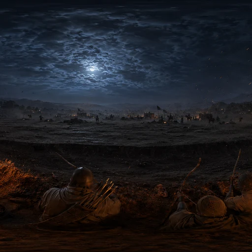
In the month of Shawwal in the fifth year after the Hijrah, traditionally placed in February 627 CE, a coalition of Quraysh from Makkah, the Banu Ghatafan, and allied tribes, about ten thousand men in the most commonly cited estimate, marched on Madinah. The early Muslim community at Madinah, far smaller, would have faced the coalition in open ground at heavy disadvantage. According to Ibn Ishaq's Sirah and al-Waqidi's Maghazi, the Persian convert Salman al-Farisi proposed digging a trench (khandaq) across the open northern approach to the city, drawing on a Sasanian-Iranian military technique not previously used in Arabian warfare. Volcanic basalt fields, the Harrat al-Madinah, naturally protected the city's other sides. The trench was dug over a period of days with the participation of the whole community. The Confederate army arrived, found the trench impossible to cross at speed, and settled into a siege that the sources put at around twenty-seven days. The siege broke without a decisive battle: a combination of dissension within the Confederate coalition (worked on, according to the sources, by the Madinian convert Nu'aym ibn Mas'ud), shifting allegiances, an exceptionally cold and stormy night, and dwindling supplies caused the besiegers to withdraw. Few combatants on either side were killed during the encounter itself. The Khandaq is conventionally treated as the strategic turning point at which the Quraysh and their allies effectively abandoned their long campaign to destroy the Muslim community at Madinah. This scene depicts the northern defense line during the siege, looking out across the trench toward the Confederate encampment in the middle distance.
What you see
A flat, dusty plain bounded on two sides by jagged black volcanic basalt fields, the Harrat al-Madinah lava flows that historically channelled any attacker on Madinah toward a single open corridor from the north.
A rocky basalt outcrop rises in the middle distance to the south, Jabal Sala', a low landmark on the north edge of historic Madinah, with the dense date palm groves of the oasis beyond it.
A wide, deep trench cuts across the entire open plain from one lava field to the other. The earth piled along the inner lip forms a long rampart; the trench bed is recently dug, the basalt-and-sand spoil still raw and unweathered.
Picks, shovels, and woven palm-fibre baskets lie along the rampart where the digging is still being finished. The tools are improvised and varied rather than uniform military equipment, the work of a community digging together rather than a standing army.
Smoke rises from small cook-fires in the defenders' line on the inner side of the trench. Goat-hair tents are pitched in compact clusters and watchposts are set at regular intervals. No banners, no parade ground, no royal standard, a defensive militia rather than a campaigning army.
On the far side of the trench, kilometres away, the encampment of a much larger force stretches across the plain. Hundreds of tents, picketed horses and camels in long lines, and isolated columns of smoke. No assault is in progress, the besieging army is camped, waiting, with no clear means of crossing the trench under cover of archery from the inner side.
The trench itself, rather than any single person or banner, is the focal feature. It is a tactical innovation in Arabian warfare of the period and the reason this engagement is remembered as the Khandaq, 'the trench', rather than by the name of a battlefield.
The air is cool and the light is low, winter sun in western Arabia. The siege is documented in the month of Shawwal in the fifth year after the Hijrah, corresponding to February or early March in the solar calendar.
Primary sources
Ibn Ishaq / Ibn Hisham, Sirat Rasul Allah (compiled 8th-9th c.): Foundational biographical compilation. Provides the narrative of Salman al-Farisi's proposal of the trench, the community digging, and the day-by-day course of the siege. The textual basis of almost all later accounts.
Muhammad ibn 'Umar al-Waqidi, Kitab al-Maghazi (early 9th c.): The most militarily detailed early account. Gives troop estimates, the trench's dimensions in places, named the units stationed along it, and the role of Nu'aym ibn Mas'ud in fracturing the Confederate alliance. Sometimes used with caution by later traditional scholars as more narratively elaborated than Ibn Ishaq.
al-Tabari, Tarikh al-Rusul wa-al-Muluk (early 10th c.): Compiles and cross-references earlier sources. Supports the dating in Shawwal 5 AH and the broad sequence of events.
Ibn Sa'd, al-Tabaqat al-Kubra (9th c.): Used for the demographic and tribal composition of both the defenders and the Confederate coalition.
Further reading & cross-references
W. Montgomery Watt, Muhammad at Medina (Oxford, 1956): Standard mid-twentieth-century English academic treatment of the Madinian period of the Sirah. Used for the strategic framing of the Khandaq as the turning point of the broader Madinah-Makkah conflict.
Martin Lings, Muhammad: His Life Based on the Earliest Sources (1983): Accessible English narrative drawn directly from Ibn Ishaq, al-Waqidi, and al-Tabari. Used for clean prose rendering of the source material; the scholarly synthesis behind it is the early Arabic tradition.
Sites and toponymy around modern Madinah: Jabal Sala' (Jabal Sala' / Sila' / Sal'), the small basalt outcrop on the north-central edge of historic Madinah, is the most commonly identified topographical anchor for the line of the trench. Modern Madinah has expanded far past the historic city, so any precise coordinate is approximate; we treat location precision as 'regional', not 'exact'.
Questions & answers
- Where is The Trench of Madinah?
- Northern approach to Madinah, near Jabal Sala'
- When did it happen?
- 5 AH / 627 CE
- What is the story of The Trench of Madinah?
- In the month of Shawwal in the fifth year after the Hijrah, traditionally placed in February 627 CE, a coalition of Quraysh from Makkah, the Banu Ghatafan, and allied tribes, about ten thousand men in the most commonly cited estimate, marched on Madinah. The early Muslim community at Madinah, far…
Related places


Guess places like this in GeoSiyer
Drop into a 360° scene from Islamic history and pin where, and when, it happened.
Play GeoSiyer