The Suez Canal Opens
A sea-channel cut through the Egyptian desert, 1869
1286 AH / 1869 CE
 Educational historical reconstruction
Where
Port Said, mouth of the Suez Canal
31.2653, 32.3019 · View on OpenStreetMap
Background
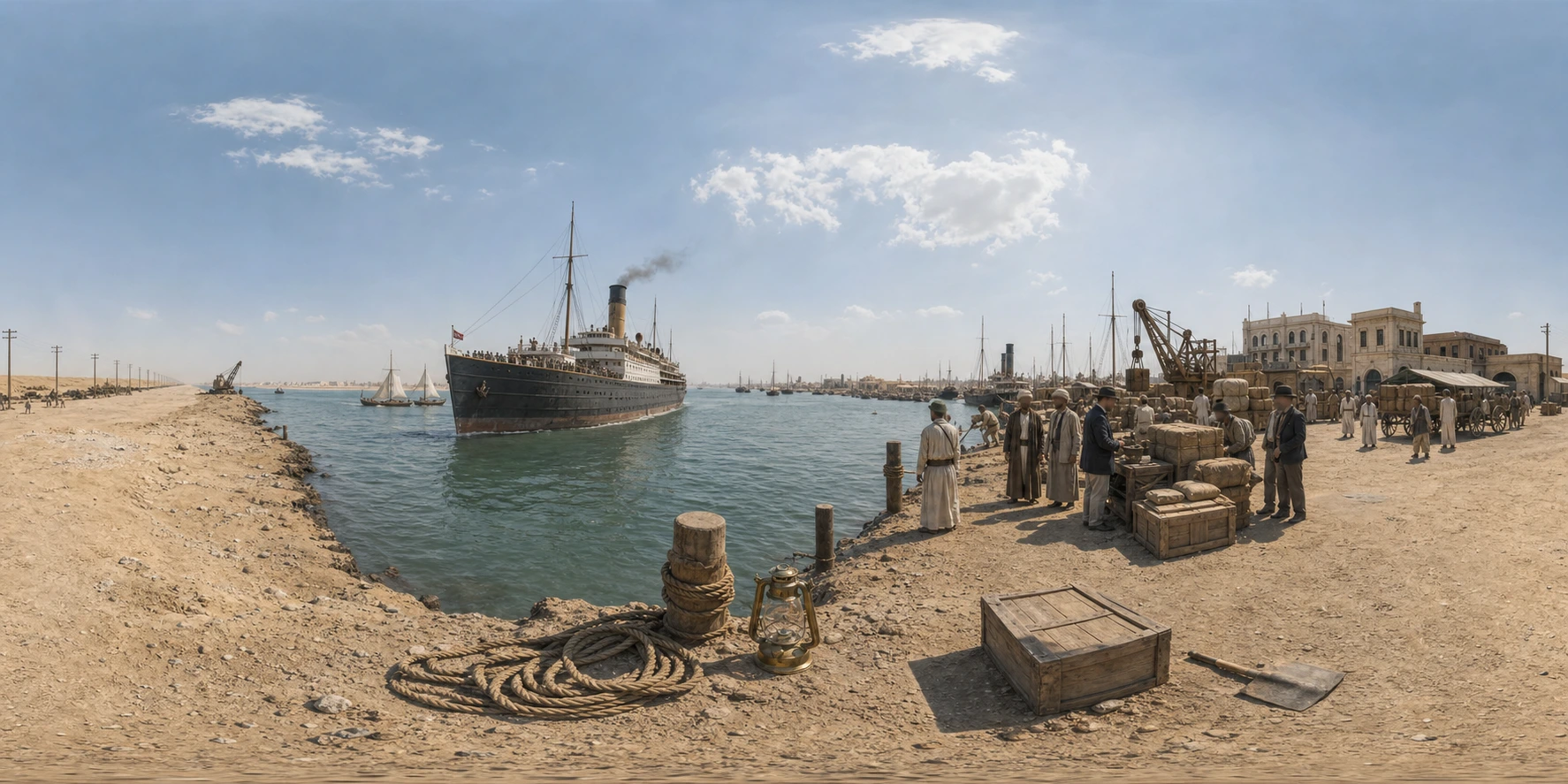
In November 1869 (1286 AH) the Suez Canal was opened, a sea-level channel cut for some hundred and sixty kilometres through the desert isthmus that had joined Africa to Asia and separated the Mediterranean from the Red Sea. It was the great project of the Khedive Ismail (rahimahu Allah), the ambitious modernising ruler of Egypt, carried out by the French-led Suez Canal Company under Ferdinand de Lesseps, and it was dug in large part by the forced labour of Egyptian peasants under the corvee, of whom great numbers died in the work before the system was curtailed. The canal transformed world trade and the route from Europe to India and the East, and its Mediterranean mouth grew a wholly new port city, Port Said. Ismail meant the canal and his other works, the railways, the rebuilt cities, the schools, to make Egypt a modern power and famously said he wished it to be part of Europe; the opening in 1869 was celebrated with extraordinary lavishness. But the cost ruined the Egyptian treasury: within a few years Ismail was forced to sell Egypt's shares in the canal to the British government in 1875, foreign controllers took charge of Egypt's finances, and the mounting crisis led directly to the British occupation of 1882. The canal thus stands as a double symbol, the achievement of a modernising Muslim state and the instrument by which it lost its independence. This scene depicts the waterway at its opening, the straight channel through the desert, the mingled steam and sail, and the new port town of Port Said.
What you see
A dead-straight channel of water runs to the horizon through flat, low desert, with no hills and only sand and salt flats on either side. This is an artificial cut across an isthmus, not a natural river or strait.
Steamships with tall funnels and old sailing vessels share the new waterway together; the mix of steam and sail marks the threshold of the steamship age.
A brand-new port town of warehouses, coaling wharves, a breakwater and a lighthouse stands at the channel's Mediterranean mouth, raised on reclaimed ground for the canal traffic.
Flags and a festal flotilla mark a grand opening ceremony; this is the inauguration of the waterway, watched by a crowd of dignitaries and ships dressed overall.
A sea-lane cut by Egyptian labour through the desert to join two seas, shortening the route to the East, marks both the ambition of a modernising Egypt and the lever by which foreign powers would soon take hold of it.
Further reading & cross-references
Egyptian chronicles and the records of the Khedive Ismail's reign (later 19th c.): Arabic and Ottoman-Egyptian accounts of the canal project, the corvee labour and the opening. Used for the Egyptian side of the works and their cost. Confidence medium to high.
Zachary Karabell, Parting the Desert: The Creation of the Suez Canal (2003): Standard modern history of the canal's construction and opening. Used for the engineering, the labour, and the financial consequences. Confidence high.
Afaf Lutfi al-Sayyid Marsot, A History of Egypt (and works on Ismail's Egypt): Used for the khedival modernisation, the debt crisis, and the road to the British occupation. Confidence high.
Suez Canal Company records and the Port Said townscape (material / cross-reference): Company records and the surviving early fabric of Port Said constrain the depiction of the canal mouth, the port and the opening; used for date and material, not framing.
Questions & answers
- Where is The Suez Canal Opens?
- Port Said, mouth of the Suez Canal
- When did it happen?
- 1286 AH / 1869 CE
- What is the story of The Suez Canal Opens?
- In November 1869 (1286 AH) the Suez Canal was opened, a sea-level channel cut for some hundred and sixty kilometres through the desert isthmus that had joined Africa to Asia and separated the Mediterranean from the Red Sea. It was the great project of the Khedive Ismail (rahimahu Allah), the…
Related places



Guess places like this in GeoSiyer
Drop into a 360° scene from Islamic history and pin where, and when, it happened.
Play GeoSiyer